Commentary by Prescient Weather co-founder Richard James, Ph.D
A recurring topic of interest and controversy among climate researchers is the potential connection between rapid Arctic warming and volatile or extreme weather in the mid-latitudes. The Arctic has warmed much faster than the rest of the globe – a phenomenon known as “Arctic amplification” – and some have argued that this is causing disruption to the jet stream and increasing volatility in weather patterns at lower latitudes.
Arctic Amplification Causes Mid-Latitude Cooling?
While it is far beyond the scope of this post to discuss the many facets of the science, one of the more counter-intuitive proposals is that Arctic amplification has caused mid-latitude winters to see “almost no warming” across land areas in recent decades (to quote Cohen at al 2020). The basic idea is that rapid Arctic warming has weakened the polar vortex, allowing cold air to spill south into the mid-latitudes more often than in previous decades. This north-south transfer of air is associated with high-latitude blocking and a more “wavy” jet stream, in contrast to the strong westerly flow that accompanies a strong polar vortex with cold “locked up” near the pole.
The hypothesis that Arctic amplification weakens the polar vortex, promotes blocking, and cools the mid-latitudes has been controversial since it was first proposed almost a decade ago, and a brief article published recently expresses the contrary view – that there is no real evidence for the proposed mechanisms. Here’s a link to a read-only version of this new article by Blackport and Screen:
Weakened evidence for mid-latitude impacts of Arctic warming
Blocking and the Polar Vortex
In light of this new contribution, it is interesting to look at a few key aspects of the problem using World Climate Service data. First, it’s worth noting – in agreement with Blackport and Screen – that Arctic-wide blocking has simply not increased in parallel with the dramatic loss of Arctic sea ice. In contrast, there’s a clear case to be made that the winter jet stream has often been stronger and more uniformly westerly in recent decades than before the era of strong Arctic warming.
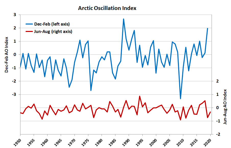
The chart below shows the Arctic Oscillation (AO) index since 1950 for winter (blue) and summer (red), and it’s clear that the December-February index values have been generally more positive since 1988 than before. If we focus only on 1988-present, as Cohen et al. did, then we might claim a downward trend through about 2013, but the larger context tells a different story.
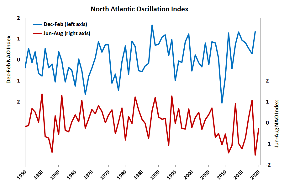
The North Atlantic Oscillation, which is closely related to the AO but focuses on the jet stream behavior over the North Atlantic sector, shows a similar picture; it’s been 10 years since there was a significantly negative NAO phase in winter (see below). I see no evidence of increased winter blocking (more negative NAO), but rather the reverse is true for the full period since 1950. However, it certainly is interesting to see that the summer NAO has frequently been significantly negative in recent years. This reflects an association between summer weather patterns and sea ice loss – but which causes the other is difficult to say.
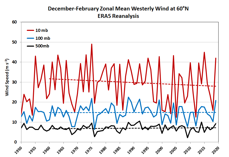
If we look at the strength of the winter-time westerly winds at 60°N (a latitude that’s commonly used to monitor the status of the stratospheric polar vortex), there is zero trend from 1960-present in the lower stratosphere (100mb) – see below. Higher up, at 10mb, the ERA5 reanalysis data suggest a slight decrease in winter westerly flow, but the trend is nowhere near statistically significant. At 500mb, in the mid-troposphere, there’s a slight increasing trend, but again not significant.
These results support Blackport and Screen in their contention that there’s no convincing evidence for the purported mechanism for increased mid-latitude volatility; the winter-time jet stream and polar vortex have not weakened, and if anything the large-scale circulation modes (AO and NAO) have become less favorable for mid-latitude cold outbreaks in winter.
Mid-Latitude Winter Temperatures
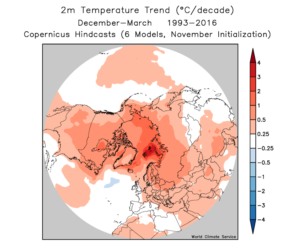
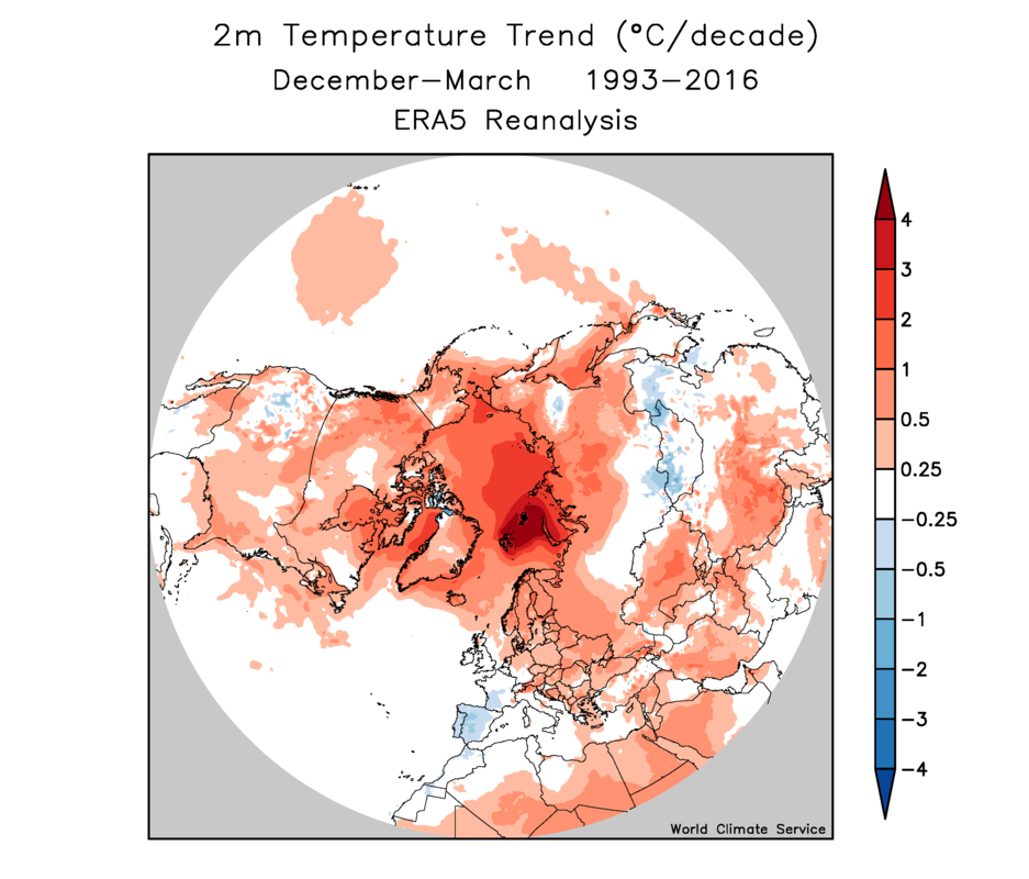
It also seems there is little reason to believe that mid-latitude land areas have seen “almost no warming” (to quote Cohen et al) in winter during the era of Arctic amplification (i.e. the last 30 years or so). Here’s a chart showing recent mid-latitude land area temperature trends for December-March from various sources (December-March was used by Cohen et al).
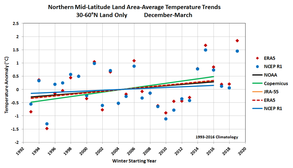
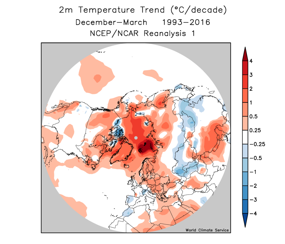
Here I’ve calculated trends for 1993-2016, which is the period for which model forecasts are available from the seasonal dynamical models included in the EU’s Copernicus program. I’ll comment on these models below. For now, notice that the smallest warming trend is found in the NCEP global reanalysis (“R1”), and this is the source that was used by Cohen at al to support their statement that “the observations show that temperatures across the midlatitude continents have remained nearly constant”. Unfortunately, the NCEP reanalysis is a 25-year-old model that runs at a very coarse resolution and simply doesn’t represent the state of the art for climate reanalysis.
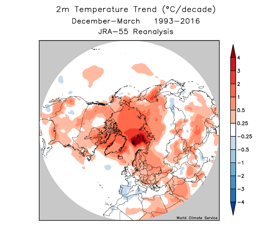
In contrast, the modern ERA5 and JRA-55 data sets show greater warming trends and agree closely with each other. These also agree quite closely with data from NOAA’s surface temperature analysis, which is obtained directly from surface observations rather than estimated from a model. It’s clear that these other sources have tended to be warmer in recent years, and cooler in earlier years, than NCEP R1 (with all series having the same zero-anomaly baseline here). If we had measured the temperature trends ending in 2013, then the sequence of cold winters around 2009-2013 would have supported the idea of greater cold air discharge to the mid-latitudes, but the last several years have done the opposite.
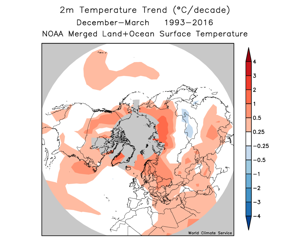
Having said all this, it is interesting to see that the observed mid-latitude warming has not been as great as the Copernicus models expected in their November-issued forecasts for December-March (as illustrated by the green trend line above). Compare the two maps below, showing the spatial distribution of trends in the Copernicus and ERA5 data. The Copernicus forecast models show considerably more warming in central and eastern Canada and the contiguous U.S., and there’s also a much broader zone of warming in western and central Russia. ERA5 even shows a few areas of cooling, but these aren’t captured in the Copernicus forecasts.
It seems fair to say, then, that mid-latitude temperature trends in the past couple of decades have not conformed entirely to model expectations, as warming has not been as widespread and pronounced as the models predicted. This much is consistent with Cohen et al, and so I think we can’t yet rule out the possibility that Arctic amplification has a systematic effect that dampens warming in the mid-latitudes. However, if this is happening, it’s not because Arctic-wide blocking has increased or the polar vortex has weakened.
In my view, the most likely explanation for the relatively small mid-latitude warming is that natural variability of weather patterns (such as the colder period of 2009-2013) has produced a trend on the low side of what might be expected. With only about 30 years of data to work with in the era of Arctic amplification, sample size is obviously a huge problem for assessing whether the models are “right”. Time will tell, of course; but I suspect we will eventually dismiss the counter-intuitive idea that Arctic warming causes mid-latitude winter cooling.
For the sake of completeness, here are the temperature trend maps for NCEP R1 (very unrealistic cooling over Asia), JRA-55, and NOAA.
And here’s a chart of high-latitude trends, for both land and ocean:
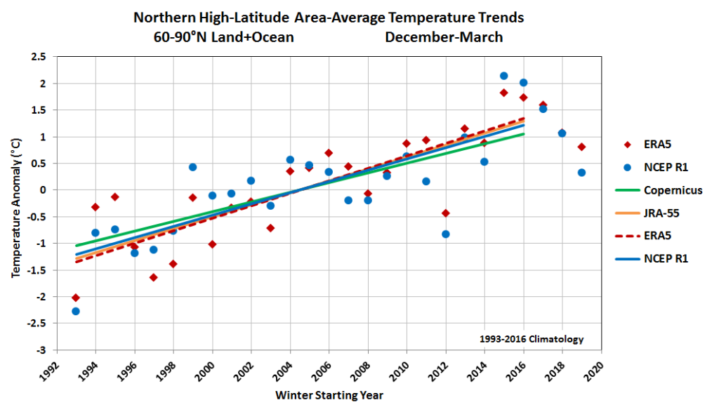
In this case the reanalysis products show more rapid warming than the Copernicus models – the opposite of the situation in the mid-latitudes. As noted by Cohen et al, the models show warming “more equitably distributed between the Arctic and midlatitudes”; they argue that this is because Arctic amplification favors greater “meridional exchange of air masses” than expected by the models, but as discussed above, the lack of increased blocking suggests this cannot be the case.